Published February 16, 2016 08:56PM
Climbing Gamlang Razi to Determine Myanmar's Highest Peak
When a team of American climbers sets off for Myanmar to determine the highest point in Southeast Asia, they find that the answer matters less than the question
"None"
This story originally appeared in the September 2014 issue of our print edition.

“Exploration means days of boredom punctuated with moments of ecstasy. As for the sake of these moments, the explorer is prepared to be something of an ascetic and accept the rest.”—Francis Kingdon-Ward, The Plant Hunter’s Paradise
“Would you like Ang to read your horoscope?” our translator Soe Thu Win asks. I look at the curling, serpent script–filled almanacs and the old man who would divine my prediction from them. Out of approximately 300 ethnic Tibetans in Myanmar, Ang Cho is said to be the only one who is literate. So saying yes seems opportunistic at the very least. But I’m hesitant, fearful of what he might say.
I did not arrive at his hearth, in the village of Zondham, nearly 900 miles north of Myanmar’s capital, Yangon, easily. We’ve walked 156 miles over 11 days through thick, dank jungle. Our objective, an unclimbed 19,000-foot peak called Gamlang Razi, is still 30 miles away and 13,000 feet higher. I say yes and take a gulp of corn whiskey.
ADVERTISEMENT
Ang Cho asks my birthday and flips through a thick tome filled with Tibetan script, explaining how cross-referencing these texts can divine all sorts of future events, from something as simple as when an expected visitor might arrive to as serious as a death. As he flips the yellowed pages, I realize I’m holding my breath. I could really use some good news.

I’d come to Myanmar to climb a mountain in the sliver of the Himalaya that reaches into the Venn diagram of India, China, and Myanmar’s ill-defined borders. Not only was the peak unclimbed, but mapping discrepancies we’d uncovered indicated that our objective, Gamlang Razi, might be higher than Hkakabo Razi, the mountain long considered to be Myanmar and Southeast Asia’s highest. For me, there was another motive: After two and a half years in and out of surgeries, physical therapy, extended light duty for a major knee surgery gone wrong, and then a rare spinal cord condition, which for a while made me unsure I’d ever climb again, I was finally mountain-ready. Gamlang Razi offered a chance to fill up on the soul-fuel of which I’d been so starved.
Ang Cho finishes my reading. It’s accurate, if a little vague, like any backpage horoscope. Yep, I’ve had some difficulties this year. Yep, things are getting better. But there is no prediction of tragedy or triumph related to the mountain we’ve come halfway around the world to climb. He simply says that if I want to accomplish something, I should put my mind to it, and it will be possible. And so we organize our loads.
ADVERTISEMENT
As we head deeper into Hkakabo Razi National Park’s jungle, I replay over and over my time by Ang Cho’s fire. I worry that the ambiguity means he divined something he didn’t want to share. He knows enough to know the importance of the days that lie ahead.

Six months earlier, American climber (and my better half) Andy Tyson and Burmese climbers Win Ko Ko, Po Pin, and Than Pai Tun stood in a foggy whiteout, celebrating around the rimed summit pole at the top of the Chinese peak Haba Xue Shan (17,703 feet). It was the Burmese climbers’ highest summit to date, and the guys were elated. Andy, who’d traveled from Idaho as a volunteer instructor for a 10-day mountaineering course, considered the failing light and the pickets he’d need to place for the descent, while the rest of the group reveled with the white, red, and black Technical Climbing Club of Myanmar (TCCM) sign, snapping summit shots against the whited-out sky.
Having grown up under Myanmar’s (formerly Burma) oppressive military regime, most TCCM members had no knowledge of climbing until Steve Davis, an ex-pat determined to keep climbing while on a teaching assignment in Myanmar, introduced them to it. It was the first time they’d ever seen a climbing magazine, video, or piece of rock climbing gear. In 2011, Davis traveled with two Burmese climbers, Win Ko Ko and Pho Nge, to Thailand to show them what climbing culture was all about. They came back fired up to learn technical skills, and the Technical Climbing Club of Myanmar was born.
ADVERTISEMENT
While the dozen or so new members had nothing more than Davis’ gear and some extra shoes, and they had never heard of a dyno or a mantel, the mere action of creating their own non-governmental organization was a tremendous move in Myanmar’s tiny outdoor community. I found it genuinely inspiring that out of all the activities and passions that these Burmese could choose after years of oppression, climbing would be the one.
Now, after months of intense planning, Andy, Chris Nance, Mark Fisher, Eric Daft, and I were finally in Myanmar, joined by TCCM members Win Ko Ko and Po Pin, with a big snowy mountain that looms nearly 18,000 feet above the steaming jungle floor in our sights. Andy, our expedition leader, had stumbled upon Gamlang Razi while surfing Google Earth. That’s also how he discovered the mystery surrounding the recorded elevations of Gamlang Razi and Hkakabo Razi. Hkakabo’s 5,881-meter measurement comes from a ground-based triangulation survey conducted the old-school way by the Indian Army in 1925. That elevation was used and popularized by the British naturalist Francis Kingdon-Ward, who made several expeditions to Myanmar’s northern territory and documented his explorations in several botany books, each rife with adventure (who knew?). Takashi Ozaki, a talented Japanese climber, made the first ascent of Hkakabo Razi with local Burmese-Tibetan Namar Jonsain in 1996. Although Ozaki had an impressive resume, including the first full ascent of Everest’s North Face and six 8,000-meter peaks in winter, he was thwarted on his first attempt by crevasses too large to cross without ladders in Hkakabo’s eastern icefall. Ozaki had relied on Ward’s books for reference, further spreading the 5,881-meter measurement. However, American, Chinese, and Russian maps we researched all placed Hkakabo lower (anywhere from 5,691 to 5,758 meters) and Gamlang Razi higher. Our visits to the Harvard Map Library and conversations with GIS experts and mapping professionals were inconclusive. So, armed with a survey-grade differential GPS, our team hoped to provide a critical piece of the puzzle, a reliable measurement recorded from Gamlang’s summit. With all the contradictory data, could Gamlang Razi in fact be higher?

“Snow!” I yell to Eric. It is another day in an endless jungle blur of sweating like a faucet, but off in the distance is a speck of white tucked into a north-facing nook, away from the equatorial sun’s rays. Finally, proof that the high mountains we’d come to climb actually existed. We’d hiked down and up countless accordion-like ravines, battling leeches, sandflies, swarms of bees, unholy temperatures, and humidity, and frankly I began to wonder if we’d ever see the mountains.
As Southeast Asia’s largest intact temperate rainforest, the area is home to five different indigenous tribes, including poison dart–wielding pygmies, and a menagerie of weird plant and animal species like barking deer, leaf deer, and coveted medicinal plants. The area had been closed to foreigners for three years, and in some places they hadn’t seen outsiders for nearly a decade. Each night we descend upon a different village; our crew of porters, liaisons, and an eclectic entourage of hiking enthusiasts sleep in the schoolhouse or the village chief’s bamboo hut, balanced above the ground on stilts. We have walked back in time to a way of life as unplugged as it gets. But with Myanmar’s recent opening and the transformative changes that are inevitable with the development predicted to follow, the chance to be in northern Myanmar at this moment in history is a gift.
ADVERTISEMENT
Now, 156 miles in, the thick jungle transitions to gnarled webs of rhododendron and patches of trampoline moss. Four days and 30 more miles later, we arrive at our basecamp, a wonderland of dark towering pines, craggy peaks, and mazes of tall wildflowers swirling with mist (or a drenching downpour, depending on the moment). From here, we hope to set a high camp 4,000 feet above, where we can scout a ridgeline that looked promising from the satellite data. As we trek uphill, we slow our pace to compensate for the heavy loads and the thinning air. Namar Jonsain, a national hero for his first ascent of Hkakabo Razi, lopes across the steep slopes, bending down with his machete to search for prized roots like machit that attract tribesmen from all over, including illegal Chinese hunters wielding guns. He offers me a small white nugget of machit for strength and power. I flash to the last time I accepted a mysterious substance from a friendly local. It was some kind of Chinese snuff, and my nostrils burned for days. But Namar is like Myanmar’s Tenzing Norgay. I can’t resist. It’s the alpinist’s version of the sacrament direct from the Pope. I crunch down on the earthy ball. It’s bitter with no other effects.

High on the ridgeline, we find intricate traps handmade with bamboo for catching blue sheep, and even the rare sky-blue poppy Ward wrote of. But we don’t find water, so for the next seven days we ferry loads up, down, and up again through talus and alpine meadows to our high camp on Gamlang’s west side. A cold downpour accompanies us with thick fog and temperatures hovering around freezing. We’ve glimpsed the bottom quarter of our intended route, but after nearly a month, we have yet to see the summit. Lying in my sleeping bag, listening to the rain, I think the mountain doesn’t want to be climbed; she isn’t ready to reveal her mystery.
On day 31 of our journey, Marc De Keyser, a meteorologist friend from Antarctica, texts a weather report to our sat phone. It’s short but has the first mention of sun—even if cryptic—since leaving Zondham. At 3 a.m. our alarms sound, and we begin ascending in a light drizzle that turns to snow as we reach the 16,000-foot level. We scatter in the icefall’s labyrinth to scout a pathway. After 180 miles of trekking, gaining a cumulative 60,000 feet, and managing to stay healthy despite the unending threat of jungle funk, venomous snakes, and swarms of bees, I realize that in a single step it could all be over. Ultimately it’s the things we can’t control, like the weather, the snow, and the crevasses that will determine our success or our failure.
ADVERTISEMENT
“It goes!” calls Andy from his perch in the icefall. The rest of us rope up and dig our crampons into the ice.
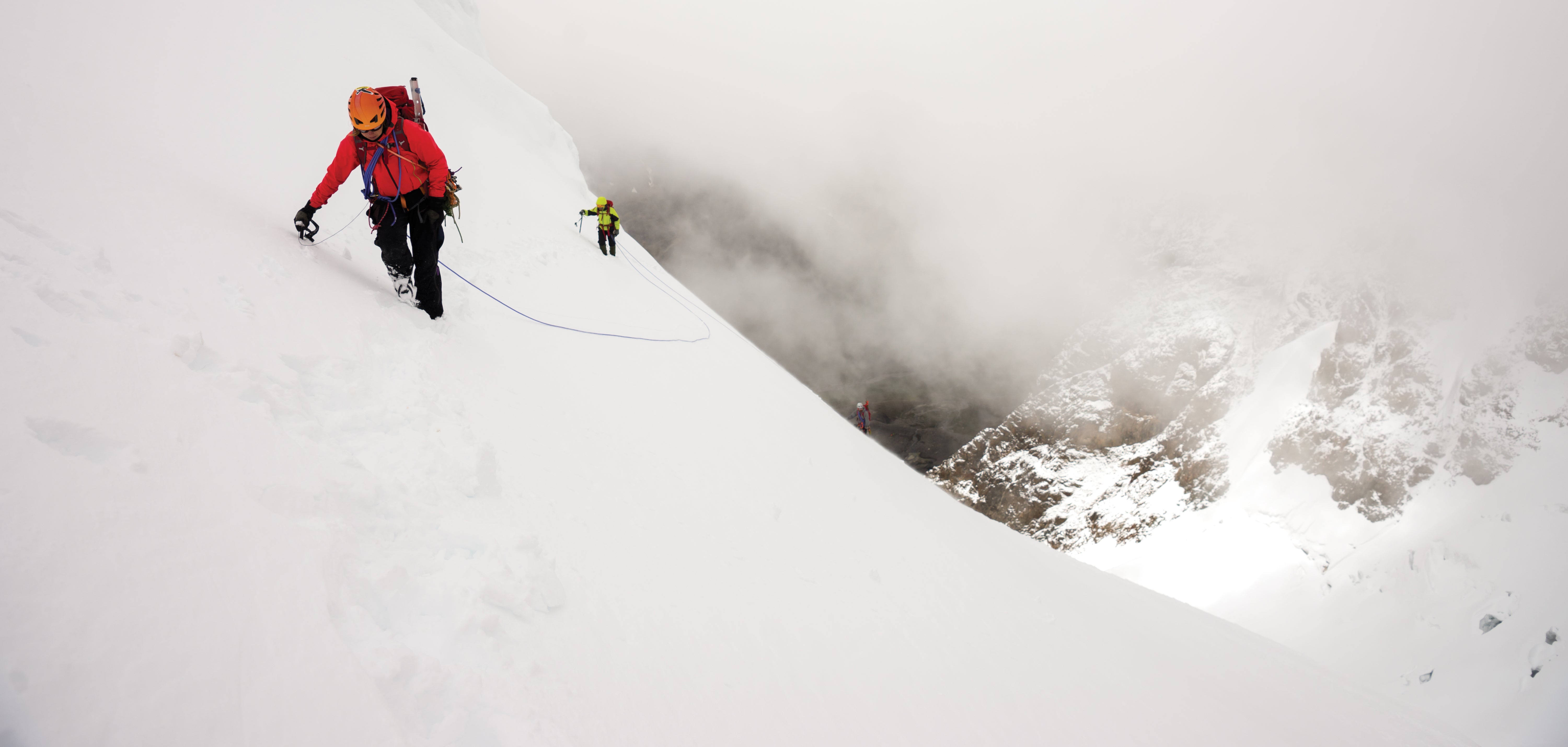
At 18,000 feet we stop. From the névé onward, the route had maintained a consistent pitch, steep enough to keep us working hard but not angled enough to bother with pro. The sky remains milky; we can’t see beyond the end of the rope team. Luckily, despite the poor visibility, the terrain naturally corralled us in the right direction. But as the gradual ramp opens into a small bowl, we hit a headwall of clean, splitter granite (just the kind we’d been looking for 3,000 feet lower). We need to catch the correct ridgeline to the left, but the clouds are too thick to discern a path. Three times we start off, wary of what might be overhead. Three times we turn around. Finally, as mutters of packing it in for the day begin surfacing, the cream thins just enough to catch the electric blue of the serac fall we’re looking for, the handrail we need that will take us to the summit.
We step-kick on, unsure of what insurmountable micro-feature might lurk ahead. We stumble into trap doors created by underlying sugary snow. We place a few pickets as the angle steepens; the ice screws and rock pro remain on our racks, for now. We break in a large wind scoop free of crevasses and gobble bars. The clouds clear again, just enough to see the snowy cap of the summit above us. Five hundred feet and what looks like less than a quarter-mile to go. It’s cold, and I keep my black balaclava tucked over my nose, my hood cinched around my helmet. The sweat and heat of the jungle feel forever ago, and for the first time in more than two years, this cockeyed plan feels like it could work. We move á cheval across the final ridgeline. I belay Po Pin onto the summit pedestal. He screams Win Ko Ko’s name (he had to turn back about an hour into the summit climb) into the wind, hyperventilating. His face streams with tears. Po Pin pulls small Myanmar and U.S. flags from his parka along with his Jehovah’s Witness prayer book for photos. Andy retrieves the GPS from a backpack where it will record 1,200 data points over the next 20 minutes, which will eventually be adjusted for satellite, barometric, and atmospheric abnormalities, calculating an average elevation of 19,258 feet (5,835 meters), or 37 feet shorter than the currently accepted height of Hkakabo Razi.

Thirty miles away, Ang Cho sits with translator Soe Thu Win.
“The mountains don’t like to be entered,” Ang Cho says. “But once they are, once they’ve been climbed, the mountains open. The team has climbed the mountain.” The rain that had been pouring down for 10 days has stopped, and the sun breaks through the clouds at 2:30 p.m. No one told Ang Cho that 12 hours earlier we’d woken in darkness to begin our climb. Is this a good tale or the truth? I don’t know, but here anything seems possible.
ADVERTISEMENT
Descending back to basecamp in a golden late-afternoon glow, we hear the stream roaring signals of the end of our expedition. Our time climbing in Myanmar is over. Despite the challenges, successes, and a lifetime of experiences to ponder, sadness floods me.
Like the rivulets running down the hillside to the basecamp stream that then runs to the river, to the ocean, and onward with the current, the quest isn’t over. It’s just the beginning.

This year a Myanmar team headed to Nepal to attempt Mount Everest. A Singapore-based Burmese man is organizing an ambitious Seven Summits circuit for a Myanmar team that will include women. Another Myanmar team will attempt Hkakabo Razi this fall. The country’s first climbing wall was just built in a Yangon backyard, and the TCCM has plans for more expeditions and crag development. Also this year, another chapter of this story will be written: Hkakabo’s measurement will be ground-truthed, also with a survey-grade GPS, and the question of what is Southeast Asia’s tallest peak will be laid to rest.
ADVERTISEMENT
After returning home, I Skyped with Takashi Ozaki’s widow, Frederique and asked her what she thought of our expedition and the height question. In a thick French accent and dragging on a cigarette in the sexy, indifferent way that only a French woman can, she said she was curious to know the answer, “But I hope Hkakabo is higher.”
We laughed, brought together by the passion, challenges, and mysteries of this far-flung place that so few will ever know. For me, this is more valuable than the answer to the question.
For more Myanmar climbing, see the video Down to Nothing: Searching for Myanmar’s Highest Peak, about an expedition to summit Hkakabo Razi.