Published October 3, 2003 03:28PM
Tech Tips - Alpine - Grin and bear it
"Tech Tips - Alpine - Grin and bear it"
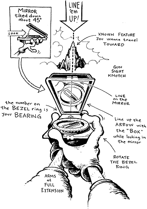
Figure 1. A simple bearing on a prominent landmark will help set your route before the clouds close in.

Grin and bear it — taking the peril out of whiteout navigation
Only minutes below our high camp on Mount Baker’s North Ridge we noticed the storm cloud racing straight toward us up the Coleman Glacier. Without stopping, my partner pulled his compass from the folds of his parka and was soon yelling directions to me through the whiteout — “Right! Right! Left! Right!” — as I broke a squiggly, vertigo-driven path. Within 30 minutes we were safely unshouldering our packs in camp. When visibility goes, confusion often arrives. Unless you have a Scottish Highlands sixth sense for whiteout navigation, knowing basic compass work is a necessity. Start by using a compass with an adjustable declination (the difference between true and magnetic north) and make sure you set the declination according to the manufacturer’s instructions. Prior to heading out, pencil in your intended route on the best topographic map you can find for the area. Bear down. In a situation where you can still see your intended objective but a storm is brewing, take a bearing (direction) on your objective so you can still find it once you’re inside the whiteout. To do this, point your compass toward your destination (Figure 1) and rotate the housing until the needle is inside the orienting arrow. Now even when you can’t see, you can keep traveling in the same direction by walking in the direction of the index line, keeping the needle inside the orienting arrow. Don’t be blind. Knowing how to find a bearing from your map when your destination isn’t visible is key to saving your butt. Let’s say you’re on a nunatak on Alaska’s Bagley Icefield. You need to cross the ice stream to reach your desired peak, but a thick layer of fog is blanketing the glacier. You can see where you want to go on your map, so measure a bearing on the map and follow this bearing to your peak. Map-to-land navigation requires you to adjust for magnetic declination, which is fairly simple but beyond the scope of this tip. The Mountaineers’ The Freedom of the Hills is an excellent reference. Don’t just strike out on a beeline for a distant object. Improve your whiteout navigation plan by dividing your route into short sections. Link each leg to a physiographic “handrail,” such as a medial moraine or ridge, that can be found and followed even when visibility is poor. When your final destination is a difficult-to-find location on a handrail, such as a hut on a glacier’s edge, use the “aiming-off” technique (Figure 2). By setting your bearing five degrees to one side of the hut, you’ll miss the hut — on purpose — but you’ll know a critical piece of information: which way to turn when you arrive at the edge of the glacier. And the most important compass tip of all? Practice, practice, practice. A compass is only as dependable as the user operating it.
ADVERTISEMENT
Figure 2. When heading for a hard-to-find point, alter your bearing by five degees so you know which direction to turn.
